idsnowghost
Staff member
The Forest Service released their proposed action on the winter travel planning in the Kaniksu zone today. This area of the forest is anything North of Sandpoint basically. When finalized the maps and rules will outline where snowmobiles/snowbikes/motorized can travel and also areas closed to travel. They have released some maps and want comments from the public at this point: https://www.fs.usda.gov/project/?project=53091
Thanks to Winter Wildlands for advocating for skiers through the workgroup process. Looks like some changes that should benefit skiers touring on foot and with sled access:
Biggest change I can see will provide some solitude for Spring skiing: as it looks like most of the forest closes after March 31 to motorized: other than some popular play areas and access roads.
Sled access to Trout Creek drainage (Pyramid/Ball Lakes, Trout Lake, Long Mountain). I pushed for that one early on in the process: there's some great skiing up there and only the road, not surrounding terrain, will be open for sled access.
Smith Creek gets designated for grooming again with motorized access near to the cabin, but closed all around it and up to the lakes and lookout.
Pack River and Beehive/Harrison open to all Nov 16-March 31. Seems as maybe the access road remains open for skiers after April 1? If so, huge win for corn skiing.
Scotchman area and some of Roundtop/Beetop area preserved as non-motorized. Though I haven't seen much activity up there myself.
Anyways, here's a map to check out the proposed changes yourself:
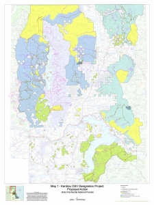
https://usfs-public.app.box.com/v/PinyonPublic/file/997073689932
More info on the project and link to make comments:
https://www.fs.usda.gov/project/?project=53091
Thanks to Winter Wildlands for advocating for skiers through the workgroup process. Looks like some changes that should benefit skiers touring on foot and with sled access:
Biggest change I can see will provide some solitude for Spring skiing: as it looks like most of the forest closes after March 31 to motorized: other than some popular play areas and access roads.
Sled access to Trout Creek drainage (Pyramid/Ball Lakes, Trout Lake, Long Mountain). I pushed for that one early on in the process: there's some great skiing up there and only the road, not surrounding terrain, will be open for sled access.
Smith Creek gets designated for grooming again with motorized access near to the cabin, but closed all around it and up to the lakes and lookout.
Pack River and Beehive/Harrison open to all Nov 16-March 31. Seems as maybe the access road remains open for skiers after April 1? If so, huge win for corn skiing.
Scotchman area and some of Roundtop/Beetop area preserved as non-motorized. Though I haven't seen much activity up there myself.
Anyways, here's a map to check out the proposed changes yourself:
https://usfs-public.app.box.com/v/PinyonPublic/file/997073689932
More info on the project and link to make comments:
https://www.fs.usda.gov/project/?project=53091