I'm just taking a quick survey... What is your favorite backcountry app and what do you end up using it for when you go out? I ask because there are so many options available that it is hard to stick with one. I've used MotionX GPS for recording tracks and I use trailforks for mountain biking. I hear there is a bc equivalent to MTB Project but I have no experience with it.
I like the idea of generating maps for bc applications. I really like the Maprika interface. Super simple and effective for locating yourself and recording tracks on homemade maps (or resort trail maps). I made this map for the backside of Mt Spokane to help avoid the drainages. I was thinking of doing something similar for the backside of Schweitzer/Big Blue/Redneck Ridge but I would like to know if there are better applications out there.
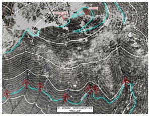
I like the idea of generating maps for bc applications. I really like the Maprika interface. Super simple and effective for locating yourself and recording tracks on homemade maps (or resort trail maps). I made this map for the backside of Mt Spokane to help avoid the drainages. I was thinking of doing something similar for the backside of Schweitzer/Big Blue/Redneck Ridge but I would like to know if there are better applications out there.