Schweitzer area snowpack

Hello all,
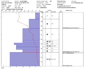
i went just out of bounds off schweitzer today and dug a pit. the snow on top is light powder and great skiing. the area i dug had about 119cm of snow and i spotted two layers worth noting, the first is down about 35cm and is where the snow gets a little denser, it was hard to get a good look at how it was reacting in a compression test because the snow above was so light it was sloughing off the column. I think the thing to note about this layer is that it could become reactive if we get more snow on it or if wind loading occurs so watch out for wind slabs in loaded areas.
The other layer of concern was 31cm up from the ground underneath a kind of crust sandwich that looked like it was from the thanksgiving snow, it was a 1 finger density layer of faceting rounds sandwiched between layers of pencil to knife density melt forms and it reacted to to a compression test at 13 taps with a sudden collapse and a propagation saw test 75/100. no results with a ECT and i think thats because the decomposing crust above it is bridging the layer for now, but it is something to keep in mind throughout the season because if it goes it will go big.
All in all a short fun day with awesome low angle skiing. have fun and be safe out there!devils creek schweitzer.jpg
 
How bad do you guys think is this December's persistent weak layer, especially Lookout pass & Bitter root valley? Do you think we're pretty much done with steep skiing until it rains or an above freezing night in March? Obviously we have a standard (good) problem of new snow atm, but you can only ski the resort for a day after the storm(tomorrow). From what I'm gathering, it seems like our typical intermountain snowpack is basically going to act like a sketchy continental one unless we get a major warm up.
 

PowderPanda

Staff member
How bad do you guys think is this December's persistent weak layer, especially Lookout pass & Bitter root valley? Do you think we're pretty much done with steep skiing until it rains or an above freezing night in March? Obviously we have a standard (good) problem of new snow atm, but you can only ski the resort for a day after the storm(tomorrow). From what I'm gathering, it seems like our typical intermountain snowpack is basically going to act like a sketchy continental one unless we get a major warm up.

Wordbird,
I haven't been in the backcountry for 2 weeks (did resort last weekend due to the heavy snow fall). In the tests that I did in Bitterroots off of Glidden, I saw that same layer at about 31cm (We had a 90cm depth at that time), but it reacted on a CTH 22 Q2. So a little dirty planer release.
This weekend, which is gonna suck, I'll dig again and see what we have going on.

I would wait a bit for sure on getting into anything too steep and out of areas that get typical wind loads or cross loads.

Also, here is IPAC's test, but note this was North of I-90 corridor so due diligence is needed.

https://www.facebook.com/Friends-of-the-Idaho-Panhandle-Avalanche-Center-129220067137315/

IPAC advisory for Silvery valley/St Regis
St. Regis Basin and Silver valley: Dan ran up to the Radar Hill area on Lookout Pass yesterday and found just under 4 feet of snowpack. The upper one foot of the pack was very cold and light and this was the new snow from the past 48 hours. Below that was the settled snow, but still low density, from the big dump from Sunday night. Lookout Pass reported 38 inches of new snow Monday morning. Dan is seeing some weak basal facets that pose some concern for future problems when we get a significant load. The weak layer at one foot deep shears easily but the overlying slab is not cohesive enough to propagate a wide fracture. Where this layer would be most problematic is where slabbed over by wind on steep terrain. More snow and warmer temps will create additional concerns with this layer. Avalanche danger is rated MODERATE on aspects steeper than 35 degrees above 5,000 feet. Avalanche danger is rated as low on slopes less than 35 degrees.
Cheers!
 
Last edited:
How bad do you guys think is this December's persistent weak layer, especially Lookout pass & Bitter root valley? Do you think we're pretty much done with steep skiing until it rains or an above freezing night in March? Obviously we have a standard (good) problem of new snow atm, but you can only ski the resort for a day after the storm(tomorrow). From what I'm gathering, it seems like our typical intermountain snowpack is basically going to act like a sketchy continental one unless we get a major warm up.
I think it's hard to say what is going to happen. It's not uncommon for us to get a warm heavy snow followed by a deep freeze that bridges over the early season snowpack but I think it's worth keeping a eye on these layers throughout the year. Right now we should watch out for windloading and new snow, the weak layer could get pretty reactive with added weight. If I see slabs stepping down to the layer 31cm up from the ground during Avalanche control work I will let you guys know for sure.
 
I think it's hard to say what is going to happen. It's not uncommon for us to get a warm heavy snow followed by a deep freeze that bridges over the early season snowpack but I think it's worth keeping a eye on these layers throughout the year. Right now we should watch out for windloading and new snow, the weak layer could get pretty reactive with added weight. If I see slabs stepping down to the layer 31cm up from the ground during Avalanche control work I will let you guys know for sure.
Well at least there is hope. But yea at this point it seems like any slopes over 30 degrees are a no go around here.
 
I've been out a bunch lately...the snow is skiing stable because it is so light...for now. Like Skibum said, it will be when we get warmer temperatures and weight on this pack that the fire works will begin. There is always a safe place to ski if you are careful with your route finding ...both up and down. Make sure you have escape route(s) on the runs you choose. There are slabs already forming, but without much moisture in the snow pack they aren't very reactive. No whoompfing, no remote propagations. The northern and NE flow is not our usual weather pattern, so pay attention even in areas you are really familiar with. Preparing via the computer is a place to start perhaps, but do your field homework as you approach the slopes you are aiming for. Last point, very different snow packs in the Silver Valley versus the Selkirks. The Selkirks did not get the huge amounts of snow that the SV got earlier this week. The SV didn't get a lot of the early dumps the Selkirks got...
Happy turns
 
Thanks PP...
Holy smokes things are changing fast in the backcountry around Schweitzer...
Froze my face off with the big winds today while out skiing 3 runs from the house. There was some freezing fog/rain early on at one point that made a nice little 1/8th inch crust on the surface. Easy to ski through, but when heavier loads come and compress the lighter layers underneath, we'll see how it reacts. Hopefully it will just go away. Getting a bit slabby, but until there is more moisture in the snow they aren't doing much more than just cracking. Lots of wind transport today! Winds from the SW, the normal flow, so lots of loading up on the lee slopes. There is a crust layer down about 18"-24" or so (SW aspect) that weak facets are laying on right now. Clean shears on that, with some effort. It is bridging the two main layers of snow at the moment, so that is a good thing. Time to get a bit cautious.
 
Hello all,
just a update about the snowpack, I dug on the west side of schweitzer today mainly looking to see if we have any of the layers that our neighbors to the north are struggling with right now and i found two layers that produced easy to moderate results with a compression test. the first was down about 17cm and got a CTE 4 and the second was down 53cm and got a CTM 17. the first layer is where the latest snow meets the old snow interface and due to it not being very dense or deep i think you would need to trigger a large area, wind slab or ski into a terrain trap to make it a problem, however if the second layer went or if the first layer stepped down to the second ( there are reports of something like this happening in Canada) you would have a problem.
Neither of the layers showed signs of propagation with a ECT and i did a PST on the layer 53cm down and i didn't get anything to propagate there, the layer 53cm down is hard to see in the pit and it has some strange looking needles above it. also worth mentioning is the 2mm scary looking depth hoar at the ground, it is deep enough that it could be hard to trigger but you might want to watch out for areas with a shallow snowpack because you don't want to mess with that stuff.
there is still great surface conditions for skiing in the backcountry right now so be safe and have fun!
 
Higgins, good stuff. I've been out a lot lately taking advantage of nice temps and really good snow. I've had the top 7"-10" (depending on location) sluffing on the firmer layer below when on steeper slopes, but nothing out of the ordinary. I did hit a really nice gully/basin on Thursday towards Baldy and saw that every one of the steep NE slopes across the way had slid in the recent warmup and storms. I'm guessing it was the layer that's about 18"-24" down in the pack. Just gives a bit of a red flag for steep NE faces. These are 40+ degrees and have some rock bands within them. I would be careful on convex rolls, around rocky areas and thin snow pack zones. A step-down is probable in the right terrain as Higgins said, as there are so many micro layers in the pack right now. It sure is skiing good though!
 

PowderPanda

Staff member
Higgins, good stuff. I've been out a lot lately taking advantage of nice temps and really good snow. I've had the top 7"-10" (depending on location) sluffing on the firmer layer below when on steeper slopes, but nothing out of the ordinary. I did hit a really nice gully/basin on Thursday towards Baldy and saw that every one of the steep NE slopes across the way had slid in the recent warmup and storms. I'm guessing it was the layer that's about 18"-24" down in the pack. Just gives a bit of a red flag for steep NE faces. These are 40+ degrees and have some rock bands within them. I would be careful on convex rolls, around rocky areas and thin snow pack zones. A step-down is probable in the right terrain as Higgins said, as there are so many micro layers in the pack right now. It sure is skiing good though!
Hadn't seen anything from ya for a bit TinyWorld.. Very good follow-up. I didn't venture out this week, needed a break. Should be interesting to see what we get with this next system and how warm in comes in on the weekend system.
 
hello everybody, i dug a pit today at schweitzer and saw about a meter of new snow on top of the old rain crust, i had moderate results with a CT test 36cm down and again about a meter down on the old rain crust. i did not see any propagation with an ECT and a PST on the rain crust started to propagate but did not carry across the column. the main problem i see is wind slab in terrain that gets loaded, we have been seeing results with explosives and ski cutting in wind loaded terrain in the resort and small avalanches with explosives in sheltered terrain. the rain crust has really helped our snowpack as far as deep instability though, there is no getting anything below that to go. great skiing out there, have fun!
 

PowderPanda

Staff member
hello everybody, i dug a pit today at schweitzer and saw about a meter of new snow on top of the old rain crust, i had moderate results with a CT test 36cm down and again about a meter down on the old rain crust. i did not see any propagation with an ECT and a PST on the rain crust started to propagate but did not carry across the column. the main problem i see is wind slab in terrain that gets loaded, we have been seeing results with explosives and ski cutting in wind loaded terrain in the resort and small avalanches with explosives in sheltered terrain. the rain crust has really helped our snowpack as far as deep instability though, there is no getting anything below that to go. great skiing out there, have fun!
Excellent info Higgins!!!!
 
I dug another pit today (4/7) when I had a break in the weather to see what the water was doing to the snowpack and it is wet! There was signs of free water running on most crusts in the snowpack down to about 130 cm deep. We had a half inch of rain overnight and there is a lot of pinwheeling going on, however we didn't get any results with a Compression test and there is still a major bridging rain crust about 45cm down that doesn't look like it's going anywhere. Overall things look pretty bomber, it looks like temps will get below freezing tonight and the snowpack is isothermal so things could be really good once we get the melt-freeze corn skiing!
 
I dug another pit today (4/7) when I had a break in the weather to see what the water was doing to the snowpack and it is wet! There was signs of free water running on most crusts in the snowpack down to about 130 cm deep. We had a half inch of rain overnight and there is a lot of pinwheeling going on, however we didn't get any results with a Compression test and there is still a major bridging rain crust about 45cm down that doesn't look like it's going anywhere. Overall things look pretty bomber, it looks like temps will get below freezing tonight and the snowpack is isothermal so things could be really good once we get the melt-freeze corn skiing!
Thanks, answers some questions I had about that crust(couldn't dig through it) when I went skiing @ Burke last weekend. Still not sure how you get a 6" thick crust in the spring in this climate however.
 
Top